
I have decided to undertake an ambitious journey that might take years to complete – hiking the entire Bruce Trail in Ontario, Canada. The Bruce Trail is a lengthy hiking trail that spans roughly 900km, following the edge of the Niagara Escarpment (one of 13 UNESCO World Biosphere Reserves in Canada). The most southern point of the trail begins in Queenston, Ontario (Niagara Falls) and it ends far north in Tobermory, ON.

The Bruce Trail is very important to our province and country as it ensures that these areas will be protected from future development and the beautiful forests will remain in place. It’s an excellent opportunity to explore the natural beauty of my province without having to travel too far from home. The Bruce Trail also has over 400km of side trails, which I’m sure we will be exploring as well if something wonderful is located down those paths, like an amazing waterfall for instance.
Posts may be sponsored. Post contains affiliate links. I may be compensated if you make a purchase using my link.
Hike #1: Niagara Falls, Ontario

At first, it looked as though it might rain, but it turned out to be one of those days where the temperature is perfect for a walk. Even though it was overcast, it was still fairly bright outside and it didn’t rain at all. Before we started our hike, we stumbled upon the Niagara Whirlpool. Of course, we had to get out of the car to check out the scenery.

The Niagara Whirlpool Aero Car operates over this section of water and we watched it travel across the gorge. It was a little bit too chilly and windy outside that day to travel across in the aero car, so we watched safely from the edge of the escarpment. However, some tourists were enjoying the ride.
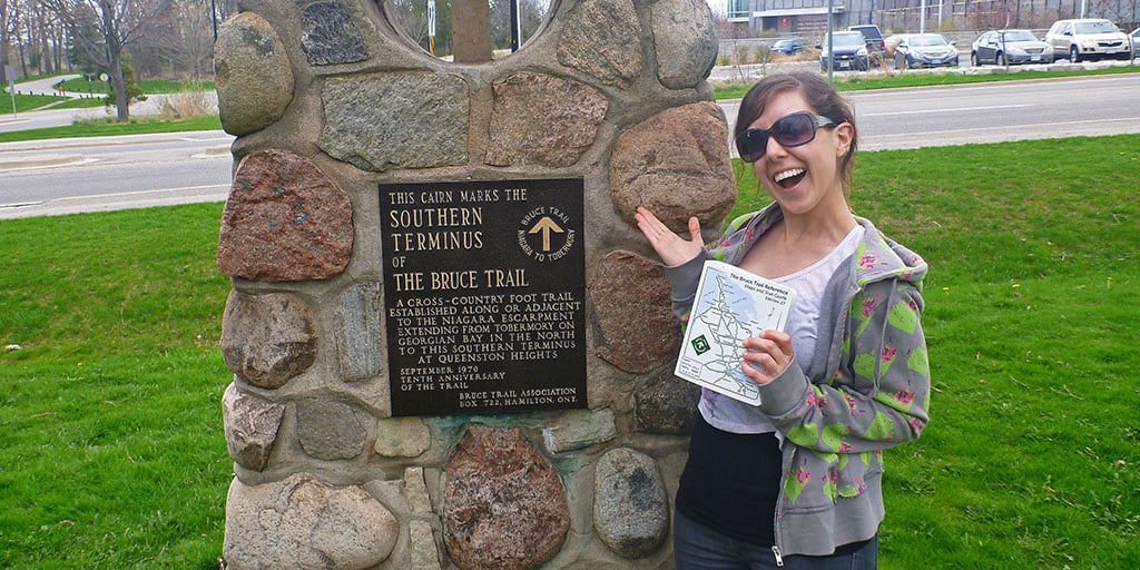
The Southern Terminus Cairn

After our short detour, we continued driving down River Road to reach Queenston, Ontario and the Southern Terminus of the Bruce Trail. This is where the journey would begin. Thankfully, I purchased the Bruce Trail Reference Guide (27th edition), which is such an excellent resource for hiking the trails. The book has full maps and detailed descriptions to help you along your way. The Southern Terminus Carirn officially marks the beginning of our hike. Justin joined me for the my very first hike on the Bruce Trail.
Despite having fairly detailed maps and descriptions of where the Bruce Trail began, we had a bit of a difficult time actually finding the Southern Terminus Cairn. We knew it was located somewhere in Queenston Heights Park…but where? It was not very clear. Thankfully, we were armed with our cell phones and Google maps, and it was easy to find using Google Street View! At last, we reached the stone monument, snapped a few photographs, and were on our way.
Queenston Heights Park

The trail started in Queenston Heights Park, and it was easy to follow the trail by looking for the white trail blazes. It’s a very relaxed, paved city park. Follow the path and the white trail blazes until you reach a forested area.


A Walk in the Forest

After a short walk through the park, we entered the forest. We were soon surrounded by trees and wildlife. It felt good to be among nature after spending the first part of the day in the bustling city of Niagara Falls. Justin was very eager to run ahead into the forest. We saw some first signs of spring – some flowers beginning to grow on the forest floor.


We also saw many small animals racing around the woods. There were plenty of chipmunks and we also saw a whole variety of squirrels. And by variety…there were your typical black and gray squirrels, but we also saw some red ones…and then, there was a red one with a white bushy tail (we actually saw this guy while driving through town earlier). I’d never seen a squirrel like that before. And later…we saw a completely white squirrel! We had both never seen a squirrel like that before. Who knew that the forests of Queenston, Ontario were home to such a diverse squirrel population!


New Discoveries
We accidentally went off the path at one point and came across some caves. It wasn’t possible to look inside as the caves were over a shallow pool of water. Unfortunately, we didn’t bring any flashlights. I’m glad we got a little bit lost and went off the main trail. Otherwise, we wouldn’t have seen the caves. Sometimes getting a little bit lost is all part of the fun!


We also came across a very interesting tall metal structure in the middle of the forest. I can’t imagine what it would have been used for. If anyone knows, please feel free to comment below.


We walked along the trail until we reached what was described in the Bruce Trail guide as a steep downwards hill. Steep was right! There was a sign posted saying “Use trail at your own risk.” (Later, on our way back, we would see someone actually running down this hill, which was pretty crazy!)


It is difficult to tell how steep the hill was from the photographs. Trust me…it was a pretty big hill! It’s a good thing that the ground was dry and it wasn’t slippery at all. We made it down to the bottom without any falling or getting dirty.

When we got to the bottom, we realized we were at the 4.2km mark on the Bruce Trail Guide Map #01. It was at the point where the Upper Canada Heritage Trail met the Bruce Trail. This meant that we turned around and walked back to the start to retrieve our car….and we had to climb up the giant hill that we just climbed down. It was great exercise!

At this rate, we might end up hiking the entire Bruce Trail twice since we walk to a certain point, and then walk back to pick up the car. Even though this might delay things a little, we will enjoy the exercise, the scenery, and the fresh air.
Want to see more photos of Bruce Trail Hike #1?
View all of our travel photography in one place! You can browse and buy any of our pictures, including prints, gifts and more.
Bruce Trail Hike #1 Stats

This map shows exactly where we walked that day, starting in Queenston Heights Park and ending at the 4.2km mark on Map #01 of the Bruce Trail reference guide. We parked our car back at the 0.0 mark and had to walk back to it, so we actually walked 8.4km that day. Not bad!
Want to read on? Here’s my Bruce Trail Hike #2!
| Hike # | 1 |
| Date | April 29, 2013 |
| Location | Map 01, Queenston |
| Distance | 4.2km |
| Total Trail Distance | 4.2km (889.8km remaining) |
| Start | Queenston Heights Park |
| Finish | 4.2 Upper Canada Heritage Trail |


Do you have any long term hiking goals?


Lauren is the full-time travel blogger and content creator behind Justin Plus Lauren. She started Justin Plus Lauren in 2013 and has travelled to 50+ countries around the world. Lauren is an expert on vegan travel as one of the very first vegan travel bloggers. She also focuses on outdoor adventure travel, eco and sustainable travel, and creating amazing travel itineraries for cities and small towns.
Kevin
Thursday 13th of August 2015
Not sure if you've found this by now, but check this link with regards to that microwave tower (the metal structure)
http://www.checkinniagara.com/2010/09/cold-war-era-radio-microwave-tower/
Lauren
Sunday 23rd of August 2015
How interesting! I had no idea. Thank you so much for letting me know! :)